Wednesday, 27 August 2008

on the road again .......

leaving Whitehorse behind at 1.30pm on Saturday July 12 2008......

by bus to Fraser (B.C. Canada)......... following photo is looking thru the window (obviously!!) of the bus, fabulous scenery all the way.

and if you are really curious, that plastic bag hanging in front of the windscreen, is hand wash!
photos really do not show what this area is like..... another photo taken thru the window of the bus:
now we are at Emerald Lake, fabulous colour and views.......

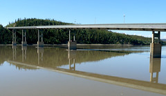
then we arrive at Fraser, BC, Canada in time to board the White Pass Rail at 2.45pm and on our way to Skagway.....

The following image is as we arrived at Fraser where the train was waiting!!

Short posting eh??

well gotta tell you am really trying to get through these postings as quick as possible ....... it is now 9.30pm on Wednesday August 27, I am so far behind with my blog it is no longer even funny!!!

It is taking a lot longer than I thought..... I still have other things to do too, upload my photos to flickr, walk the dogs, lead my normal life ..... and of course, next Saturday we are going over top Batam to see how the Villa is progressing with the renovations, we are on the home run now and it will be just 5 weeks before it is finished. Can hardly wait. :-)

Then next week John is off to the US for a couple of weeks.

Next posting will be the White Pass Rail journey....

Tuesday, 26 August 2008

flowers, plants and other greenery around Whitehorse, in the Yukon area of Canada ....

Yes, I know...... this posting was going to be about after we left Whitehorse and headed south to catch the White Pass Rail.

I just remembered that I hadn't said anything about all the flowers around Whitehorse... well they are everywhere in Alaska and the Yukon area ..... but these photos are of the beauties we saw while traipsing around Whitehorse.

First one is just some grass would you believe??? Lovely soft, fine grass growing along side the Yukon River...
a very heavily perfumed shrub (lilac?) as we did the walk along the Yukon River....
and the rest are of floral displays and other plants and greenery we came across:


love this one.....natures little printed circuit boards!!!

OK.....
promise, the next posting will be as we leave Whitehorse which was on Saturday July 12 2008
.
.

Monday, 25 August 2008

all about The Fish Ladder of Whitehorse in Canada.

On Friday July 11 2008.....

Hydro Dam & Fish Ladder,
located upstream of the Robert Campbell Bridge, is a hydroelectric dam that provides power for Whitehorse as well as the town of Faro.

The water backed up by the dam forms Schwatka Lake which has tamed the infamous Whitehorse Rapids. On the east side of the dam, you can see one of the world's longest all-wooden fish ladders.

In August, when salmon are running upstream to spawn, you can view the fish through a window at the side of the ladder.


This is part of the ladder.....

... and the walkway to view the dam and fish ladder.....
Janine on the bridge crossing over The Yukon River, we can see the dam from here.
looking downstream on The Yukon River....... huge volume of water here!!
How the fish get thru .....

The barrier dam is a low concrete structure that spans the river, preventing fish from swimming up into the turbulent water on the other side of the spillway. The concrete wall is built at an angle to direct fish to the entrance to the fishway.

The entry at the bottom of the fish ladder offers a good resting place. The flow of water in the fishway can be adjusted by valves to attract the fish into the ladder.

The ladder is built in a series of steps. It is about 366 metres long and rises over 15 metres in steps. The flow of water through each section creates a series of eddies, which allows the fish to rest between steps but still provides enough flow to encourage the fish to continue swimming.

About halfway along the ladder, the fish enter a holding area. At this point you can view the fish through the observation window in the interpretation building. Once in the holding tank, gates on both sides are closed temporarily while staff observe and record the size, sex and condition of the fish. Also at this time, some Chinook salmon are collected for the brood stock program at the Whitehorse Rapids Fish Hatchery.

Whitehorse, Yukon, Canada


www.yukonenergy.ca/services/facilities/fishway/

www.yukonfga.ca/fishway/index.asp

and the webcam to watch the fish arrive is here:

www.yukonenergy.ca/community/multimedia/fishcam/

This really was amazing place to visit, if you ever visit Whitehorse, then you really must see this Fish Ladder !


Next posting :
will probably be on our way to Fraser (BC, Canada) to catch the White Pass Rail to Skagway!

Sunday, 24 August 2008

we are now in Whitehorse, Yukon Territory .....

First impression..... nice place!

we arrived around lunchtime on the Thursday (July 10) and settled into the Klondike Inn where we had booked in for two nights. The next day was a 'free day' so we did a bit of souvenir shopping of small bits and pieces to take back to family and friends.....not too much as we had to consider the weight of our luggage too!

After our little shopping spree we went on a walk, called the Millennium Trail / Walk which followed the Yukon River, we walked as far as the Fish Ladder and did a U turn.... all up, 10 klms.

The Millennium Trail, is a 5-km paved path that follows both sides of the waterway, starts at the S.S. Klondike crosses a bridge over the river then continues to another bridge by the dam, then loops back to wear you started. It's a nice place to walk at sunset, although keep in mind that sunset in the middle of summer is near midnight! Near the dam is the Whitehorse Fishway where you can watch the migration of chinook salmon and other fish through underwater viewing windows. The following images are just a sample of what we saw on our walk.....


We really enjoyed our walk and even managed to get sunburnt and it was only 19 deg!!!
Temperature on Friday July 11 2008 in Whitehorse was:


Max Temperature 66 °F / 19 °C

Min Temperature 41 °F / 5 °C


Next Posting: The Fish Ladder in Whitehorse!


Saturday, 23 August 2008

Thursday July 10 and on our way to Whitehorse!!!

This is taking me a lot longer than I thought it would.......have not dared count how many photos I actually took while Janine and I were traveling thru Alaska and The Yukon. But it seems to be taking forever to sort thru them, upload to flickr, keep the blog as up to date as possible and just generally sorting thru the photos!!!

Anyway, on with it.....

Our last night in Dawson City and Janine and I went to Diamond Tooth Gerties for a few drinkies, a game or two of Black Jack (well that was Janine actually!!) and then a few more beers before watching the show....

what a hoot!!!

great fun night for our last night in Dawson City, where I half expected Wyatt Earp to come out with his six gun.!!

Dawson City is a place that could grow on you, at first it felt like a huge overgrown Universal Studio movie set........ but there are real people and real homes and real restaurants that add to the atmosphere of this great little place in The Yukon!

But we had to leave on Thursday morning to continue on our journey via Klondike Highway towards Whitehorse....
The above is the Five Finger Rapids.

Northern Tutchone Indian people called this site Tthi-cho nadezhe meaning 'rocks (standing up) in the water'. The five channels or 'fingers' of water are divided by four pillars of erosion resistant basalt rock. Grooves and lines along the rock walls of the river are clear signs of recent glaciation.

This valley is a major wildlife migration corridor. The slopes and cliffs below extend to the Alaska border and beyond, and are vital nesting and feeding habitat for many Yukon species.

The above image is of the Tintina Trench.

The Tintina Trench is a linear valley, extending into Alaska and southeast across the Yukon.

It was first recorded as a geological feature in the early 1900s by a geologist with the Geological Survey of Canada. Beneath the Tintina Trench is a fault line along which bedrock has shifted a minimum of 450klm laterally.

Some 65 million years ago, the rocks presently beneath Dawson City were adjacent to those of Ross River. The Trench had a dramatic impact on the river drainage system. The formation of the trench created a channel for rivers draining the interior to the south.

Later, blockages due to ice buildup during the first glacial period around 3 million years ago, caused the Yukon River system to be rerouted.

Photo taken July 10 2008 along the Klondike Highway on our way to Whitehorse, Yukon Territory.

(by very fast shuttle!!)


next posting: we arrive in Whitehorse!

.

Friday, 22 August 2008

Dawson City - a very unique place in The Yukon

Dawson City is a bustling little town with a surprising amount of services for tourists and locals alike.

http://www.dawsoncity.ca/

The population was 1,327 at the 2006 census.[1] The area draws some 60,000 visitors each year. The locals generally refer to it simply as 'Dawson', but the tourist industry generally refers to it as 'Dawson City' (partly to differentiate it from Dawson Creek, British Columbia, which is at mile 0 of the Alaska Highway).
Next image is me at our hotel...... very typical Dawson City style. With hindsight, I really wished we had stayed at a Bed and Breakast, somewhere smaller than the hotel. Klondike Kates looked rather nice and others we spoke with recommended it too.

Anywhere other than the hotels that all the tourist coaches use. Especially the Holland line or Princess Tours, too many of them in these small towns!!!

this is the Welcome Sign as you come into the area......
a couple of very typical street scenes......


We were in Dawson City for three days / two nights.

The weather on the Tuesday July 8 was 19 deg (min being 11) and on Wednesday July 9 it was 20 deg (min 6 deg).

[ 20 deg celsius is 68 deg fahrenheit ]

There are many more photos of Dawson City on my flickr site:

http://www.flickr.com/photos/leonefabre/

after Dawson City, we go to WHITEHORSE arriving on Thursday July 10 2008.

.

Thursday, 21 August 2008

summer in Dawson City ......


Summer in Dawson City. ......... . June - August


* Mother nature at her warmest
* Flowers everywhere
* Long daylight hours "Land of the Midnight Sun"
* Hiking, biking, fishing, exploring the historical beauty of Dawson
* Checking out how a gold mine works and trying your luck at finding the "motherlode"
* Shopping in the many gift shops
* Touring the galleries and museum
* Gambling and watching the floor show at Diamond Tooth Gerties
* Dawson City Music Festival (July 18 - 20)
* Discovery Days (August 13 - 18)


http://www.dawsoncity.ca/


Flowers are in anything that will hold soil and a seedling....... !!!


see previous post on Dawson City, and the next posting will be on the unique style of Dawson!!

enjoy. :-)

good morning Daisy!!


good morning Daisy!!
Originally uploaded by Leone Fabre.

...... and good morning to anyone that has just tuned in!!!

This blog is really to put my thoughts to paper .... ooop's computer, on my life in Singapore, but with living in Singapore comes travel and that is what these postings are about..... TRAVEL, not just travel, but a month of travel thru Alaska and The Yukon.

In summary, Janine and I met up in Tokyo on Saturday June 28 to travel to Anchorage where our adventure began....

but you need to scroll way down to the start or check the archives on the start of our holiday.

Right now I am up to DAWSON CITY, but this is just a very small posting on Dawson City, will post more photos etc within a day or so.

to start...flowers, flowers and more flowers .....

....everywhere and anywhere.

any container, tub, pot, wheelbarrow or even a washing machine ......there are flowers!!!

Dawson City is the heart of the Klondike Gold Rush! An incredible community that has preserved its past, Dawson City invites you to turn back the pages of time and experience the rich living history. ..... and all its beautiful floral displays!

Dawson City, Yukon, Canada . July 2008

Wednesday, 20 August 2008

Chicken, Alaska !!!

Why Do They Call it "Chicken?"

info from the Chicken website states:

Good Question. In the late 1800's, early miners traveled far in search of gold. Food was sometimes scarce, but a particular area near the South Fork of the 40-Mile River was abundant in Ptarmigan, now the state bird which bears a resemblance to a chicken (Ah the foreshadowing is thicker than steel.) The miners kept themselves alive with the help of the Ptarmigan (if you consider being eaten as helping.)

In 1902, Chicken was to become incorporated, the second town in Alaska to do so. The name "Ptarmigan" was suggested. Many people liked the name, but felt the quotation marks were too presumptuous. The name was shortened to Ptarmigan.

The only problem was that nobody could agree on the correct spelling. They didn't want their town name to be the source of ridicule and laughter, so they decided on "Chicken." (The irony is thicker than the foreshadowing.)


This photo is of the CHICKEN POOP, as in the male and female loo:


This is of the CHICKEN POST OFFICE ...... small, but servicable!

Now these two photos are of the ABC pies sold in the Chicken Cafe...

ABC ? I hear you say!

Yes,

A is for APPLE, B is for BLUEBERRY and C is for CHERRY !!

they are so delicious:


and to read more about the little township of Chicken, check out the website:

http://www.chickenalaska.com/chicken/index.html

Next posting we are on our way to DAWSON CITY ........ wahooo!!!

Tuesday, 19 August 2008

Chicken Menu !!!


Chicken Menu !!!
Originally uploaded by Leone Fabre.

The menu at Chicken...... but the chili is the best of all, oh yes and the ABC pies........ :-))

The day after our Arctic Circle trip on July 7 2008, we headed east on the Top of The World Highway from Fairbanks to Dawson City in The Yukon. Our first stop - which was for lunch - was at CHICKEN!

Why Do They Call it "Chicken?"

check the website to find out. :-)

www.chickenalaska.com/chicken/index.html

en.wikipedia.org/wiki/Chicken,_Alaska

there are no phones, no central plumbing and mail comes in on Tuesdays and Fridays, the population varies between 17 and 37, depending on who you ask!

... and General Travel Info:

The Taylor Highway is made of packed gravel. Trucks, cars, and motorhomes regularly travel the road. The highway is open from Spring to early Fall. Paving is expected in the same year that pigs begin to fly.

but I tell you, they do have the best damn Chilli in all Alaska!!!

(next posting will have more photos of downtown CHICKEN!

:-)

Monday, 18 August 2008

more photos of TAPS .......

The Trans-Alaska Pipeline System (TAPS), usually called the Alyeska Pipeline in Alaska or the Alaska Pipeline elsewhere, is a major U.S. oil pipeline connecting oil fields in northern Alaska to a sea port where the oil can be shipped to the Lower 48 states for refining.

The main Trans-Alaska Pipeline runs north to south, almost 800 miles (1,300 km), from the Arctic Ocean at Prudhoe Bay, Alaska to the Gulf of Alaska at Valdez, Alaska, passing near several Alaskan towns, including Wiseman, Bettles, Livengood, Fox, Fairbanks, and Glennallen.


These are just some of the images taken of this awesome project...... see previous posting for more info and photo.

I really did find this whole project amazing, the work that went into it, the workers, the actual construction, everything. I wished I had found more time to see it even further north.

But well worth the time and effort to locate more info about it on the net if you are interested.

.
next posting we are on our way to Dawson City............ :-)
.

Part of the The Trans-Alaska Pipeline System (TAPS)


Part of the The Trans-Alaska Pipeline System (TAPS)
Originally uploaded by Leone Fabre.

July 7 2008 - took a tour to the Arctic Circle, a trip of some 185 Klm (115 miles) north.

On the way we saw the amazing Trans-Alaska Pipeline ..... an awesome structure. I really was impressed by all the work that went into the construction of it.

...... and from Wikipedia:

The Trans-Alaska Pipeline System (TAPS), usually called the Alyeska Pipeline in Alaska or the Alaska Pipeline elsewhere, is a major U.S. oil pipeline connecting oil fields in northern Alaska to a sea port where the oil can be shipped to the Lower 48 states for refining.

The main Trans-Alaska Pipeline runs north to south, almost 800 miles (1,300 km), from the Arctic Ocean at Prudhoe Bay, Alaska to the Gulf of Alaska at Valdez, Alaska, passing near several Alaskan towns, including Wiseman, Bettles, Livengood, Fox, Fairbanks, and Glennallen.

Construction of the pipeline presented significant challenges due to the remoteness of the terrain and the harshness of the environment it had to pass through. Between Arctic Alaska and Valdez, there were three mountain ranges, active fault lines, miles of unstable, boggy ground underlain with frost, and migration paths of caribou and moose. Geological activity has damaged the pipeline on several occasions.

Since its completion in 1977, the pipeline has transported over 15 billion barrels (2.4 Tl) of oil.

But this is just one of the photos taken of this awesome project!!

more in next post!!!

Sunday, 17 August 2008

to the Arctic Circle we do go ......

I know! I know!

you are wondering why I am writing about the Arctic Circle instead of Singapore eh?

For those that have "just tuned in" may very well wonder why I am not talking about MY LIFE IN SINGAPORE ..... be rest assured friends, I will get back to that eventually!

Its just that while here in Singapore I had the opportunity last July (2008) to take a trip to Alaska with my daughter ........ now, no one in their right mind would pass up an opportunity such as that!

So I need to get thru my holiday there (nearly a month) before I can get back to Singapore tales....... but there is still plenty about Singapore if you care to go hunting thru the archives, otherwise wait a bit and we will get back to MY LIFE IN SINGAPORE once I have finished telling you about Alaska and The Yukon!

Now, where was I?

oh yes........ off to the Arctic Circle.

Now while we were in Fairbanks we decided to take a slight detour to check out the imaginary dotted line called the Arctic Circle..... would have loved to have done the Mail Run by plane or perhaps gone up as far as Barrow by plane....but hindsight is a wonderful thing to have after the event.

So we chose the all day (17 hours) Arctic Circle Drive Adventure tour and we were very happy with that .... we saw a lot and learn't so much. Well worth every minute of the trip. It is run by the Northern Alaska Tour Company out of Fairbanks.

http://www.northernalaska.com/arcticcircle.cfm

highly recommended.

now that I have finished with the advertizing......lets get on with the photos...... !!!

now this first one is of Janine and I about to cross the Arctic Circle....... oh dear, the allure of an imaginary dotted line is so irresistible!

but the rest of the images are just a very small sample of some of the best scenery we saw along the Dalton Highway and beyond..... in this one you can also see the Alaska Pipeline, but maybe I will do a separate 'posting' for that as it was so amazing!


just a very small sample, but so beautiful. The Tundra area was amazing as much as it was beautiful. The story of the Alaska Pipeline is incredible and well worth reading about. My next posting will be the Alaska Pipeline.

I really did enjoy this trip and the 17 hours of travel passed by far too quickly. It is an area of the world that deserves more than "just a day trip".


stay tuned for the next posting ......... The Alaska Pipeline.