Monday, 29 September 2008

Tuesday July 22 2008...... we arrived in Melbourne, VIC, Australia!!!

These images were taken after we left Melbourne International Airport and headed towards Trentham in a hire car. We drove to Woodend to have our Vanilla Slices (Woodend Bakery, where else?) and then onto Trentham to pick up Janines dog - Zac - who had been cared for by family friends while we were away.

these two images are very typical of the Victorian Countryside around Woodend, Tylden, Trentham and Blackwood areas.


NEXT POSTING..... hopefully back in Singapore!!!!!

Sunday, 28 September 2008

coming into land at LA International Airport, California, USA

Flying over Los Angeles on Sunday July 20 2008.

First image shows:
Rancho Park Golf Course.
Hillcrest Country Club.
Los Angeles Country Club.
Wilshire Blvd.
Santa Monica Blvd.
View Larger Map


Second image shows:
Wilshire Country Club.
Wilshire Blvd.
San Vicente Blvd.
W. Pico Blvd.
Venice Blvd.
Hancock Park.
View Larger Map


Third image shows:
Angelino Heights.
Hollywood Fwy.
Harbor Fwy.
Dodger Stadium.
View Larger Map


Fourth image shows:
Calvary Cemetery.
Old Fellows Cemetery.
Home of Peace Cemetery
Mt Zion Cemetery
Beth Israel Cemetery
View Larger Map


Fifth image is:
Hollywood Park, California. USA


and the final image just prior to landing at LA International Airport is:
San Diego Fwy
W.Arbor Vitae Street
S.Ash Ave
Kenwood Street
Highway 405


To see all of the above images at a higher resolution, check the flickr site
here:
http://www.flickr.com/photos/leonefabre/

Next Posting: We have arrived in Melbourne, Victoria, Australia

.

Tuesday, 23 September 2008

Mt Hood and other in flight images as we fly south towards Los Angeles, California.


Mt Hood in Washington, USA.


all the rest were taken on the flight south to Los Angeles.


Next Posting: Coming into Land at LA International Airport

==============================================================

Sunday, 21 September 2008

a few aerial shots after leaving Vancouver ............... including Mt Rainier.

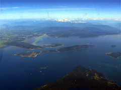
In Flight ...... QF 3788..... Sucia Island State Park, south of Vancouver!

Vancouver to Los Angeles Sunday July 20 2008

departing from Vancouver at 12.45pm, these few images taken about half an hour or so after departing Vancouver.

This aerial photo was taken about 35 - 40 mins after leaving Vancouver on our way to Los Angeles - Sunday July 20 2008.

The large Island in the lower part of the image is MERCER ISLAND. The dark green patch over to the right of that island is PIONEER PARK.

The main highway running down towards the lower left of the screen is HWY 90 (Mountains to Sound Greenway) and out of sight, way down past the lower left corner, the highway leads to SEATTLE.

The highway across the screen... left to right.... is HWY 405. With the town of BELLEVUE to the left. Far lower right of screen is the GENE COULON MEMORIAL PARK and CEDAR RIVER.

The little patch of land at the bottom centre of the screen is SEWARD PARK and the stretch of water there is LAKE WASHINGTON. Towards the top of the image is LAKE SAMMAMISH.
This aerial image looks quite 'busy' with so many places that you can see...... I hope the following description will help!

Mt RAINIER is right up (off screen) at the far top right hand corner of this image.

The township of BONNEY LAKE is lower right of the screen.

The river you see here is the WHITE RIVER and another township - BUCKLEY is at the top, centre of the image.

Now, right down at the bottom of the image are a few oval shaped islands ...... that is LAKE TAPPS and the TAPPS ISLAND GOLF COURSE.

You may like to look at this area using GOOGLE MAPS and type in LAKE TAPPS...... view it in Terrain or Satellite.

according to Wikipedia.....The White River is a river in the U.S. state of Washington. It flows about 75 miles (121 km) from its source, the Emmons Glacier on Mount Rainier, to join the Puyallup River at Sumner. It defines part of the boundary between King and Pierce counties.
Mt Rainier.....

seen thru the dirty window on a flight from Vancouver to Los Angeles... July 20 2001.

from Wikipedia....

The Carbon River is a river in the U.S. state of Washington. It flows about 30 miles (48 km) from its source, the Carbon Glacier on Mount Rainier, to join the Puyallup River at Orting.

Charles Wilkes called the river the "Upthascap River", but after the discovery of coal along its banks in 1876 the river was renamed "Carbon".

Mount Rainier is an active stratovolcano (also known as a composite volcano) in Pierce County, Washington, located 54 miles (87 km) southeast of Seattle, Washington, in the United States. It is the highest peak in the Cascade Range and Cascade Volcanic Arc at 14,411 feet (4,392 m). The mountain and the surrounding area are protected within Mount Rainier National Park. With 26 major glaciers, Mount Rainier is the most heavily glaciated peak in the lower 48 states with 35 square miles (91 km²) of permanent snowfields and glaciers.

The summit is topped by two volcanic craters, each over 1,000 feet (300 m) in diameter with the larger east crater overlapping the west crater. Geothermal heat from the volcano keeps areas of both crater rims free of snow and ice, and has formed an extensive network of glacier caves within the ice-filled craters. A small crater lake, the highest in North America, occupies the lowest portion of the west crater below more than 160 feet (50 m) of ice and is accessible only via the caves.

in flight - Vancouver to LA


in flight - Vancouver to LA
Originally uploaded by Leone Fabre.

Sunday July 20 2008

In Flight ...... QF 3788 ...... Vancouver to Los Angeles

departing from Vancouver at 12.45pm, these few images taken about half an hour or so after departing Vancouver.

Looking at Bellingham, Bellingham Bay and Lummi Island. Which is the long skinny island in the middle of the image. We would have come thru here on the M/V Columbia (Alaska Marine Highway Ferry) traveling south from Ketchikan to Bellingham. The Ferry travels to the west of Lummi Island, down around the Three Rocks area (south side) and then back up into Bellingham Bay.

There are many mountains in the background: Lookout Mountain, Anderson Mountain, Stewart Mountain etc.

Sorry about the dirty window though!!!


next Posting: more aerial shots.

Thursday, 18 September 2008

down by the waterside ................ VANCOUVER !!

All these images were taken in Vancouver, Canada
weekend of July 19 and 20 2008


lovely city and so much like Melbourne!!!

We flew out of Vancouver on Sunday July 20 and
headed to Melbourne via Los Angeles, arriving
Tuesday morning July 22 2008.

NEXT POSTING:
in flight with images of Mt Rainier etc.....

------------------------------------------------------------------------------------------------------------

Wednesday, 17 September 2008

south to Vancouver.......

After Ketchikan, we sailed south to Bellingham
in Washington where we left the M/V Columbia
on Friday July 18 2008.


We went by bus to Vancouver and stayed at
The Victoria Hotel in Homer Street.
Which was very pleasant......
everything was in walking distance.


Photo is of the hotel......

what we noticed most of all about Vancouver was that it
was so much like Melbourne!!!!!

The buildings, the streets, the people everything.....

as you will see by all the following images
taken around Vancouver.


Next posting:
down by the waterside in Vancouver.....

==============================================================

Tuesday, 16 September 2008

boarding the M/V Columbia at Ketchikan.....

......continuing our journey south thru the Inside Passage from Skagway to Bellingham on the Alaskan Maritime Highway Ferry System.

we were on the M/V Kennicott from Skagway to Ketchikan, from there we changed ferries and boarded the Columbia....

these images are on the Columbia from the time we left Ketchikan on July 16 2008.

this one is of the vehicles waiting to board:

.... and where they enter the ferry .....
Vehicles park below......
one of the dining area's ....... with a fabulous view!!!
Janine sitting at a table in one of the lounge area's, this is usually where we played scrabble or cards or were found reading.... in this image you can see the clothes we had washed and left on the window ledge to dry!!!
We had a cabin / roomette on board the Kennicott, but for the Columbia they wanted to charge us an additional $400.00 for two nights!!

Long story about cabins and their availability in earlier postings!!

Anyway, we declined to pay the extra $400.00 (especially after we only paid $33.00 on the previous ferry!) so opted to sleep in the lounge along with many others...... this image is our little corner where we bedded down....
This is the area a lot of people slept in sleeping bags etc..... too cold for us though!!!
one of the dining area's and cafe..... food was good and price not too bad considering we were on a ferry...... though a lot of people brought their own food with them on board.
the bar area .....
Janine out on deck......
another area for people to sleep on deck........ :-)

a lot of people brought tents along as well.......
you gotta be quick to grab one of these sleeping area's, as people are boarding they run to these area's to secure a good spot...... of course, most of these people have traveled on the ferries before, so know all the lurks!

We wouldn't have slept here anyway, just far too cold for us!!

but if you book early enough, make sure you get a cabin 
we were still happy with what we had,
but when we eventually got a cabin it was much more comfortable.


Next posting:

into Bellingham and Vancouver

Monday, 15 September 2008

signs of the times - in Ketchikan!

just a few of the many signs seen around the Ketchikan area, like the one above of the
Happy Bears Arctic Bar !!!!


scroll down for earlier posts on our visit to Ketchikan

July 2008


NEXT POSTING:

boarding the M/V Columbia


------------------------------------------------------------

KETCHIKAN..... if you can......

according to Wikipedia.....

Ketchikan (pronounced /ˈkɛtʃɪkæn/) is a city in Ketchikan Gateway Borough, Alaska, United States and the southeasternmost sizable city in that state. With an estimated population of 7,368 in 2007, it is the fifth most populous city in the state.

Ketchikan's economy is based upon tourism and fishing, and the city is known as the "Salmon Capital of the World." The Misty Fjords National Monument is one of the area's major attractions.

Ketchikan is named after Ketchikan Creek, which flows through the town. Ketchikan comes from the Tlingit name for the creek, Kitschk-hin, the meaning of which is unclear. It may mean "the river belonging to Kitschk"; other accounts claim it means "Thundering Wings of an Eagle."
Ketchikan's secondary post office box zip code, 99950, is the highest zip code ever assigned in the United States. Most residents use the zip code 99901. Ketchikan also has the world's largest collection of standing totem poles, located at three major locations: Saxman Village, Totem Bight, and the Totem Heritage Center.
The following are just a few photos of around Creek Street and Ketchikan.....


... and yes, it is very hilly!!


'tis a nice town, but you do need a lot longer than just one day to browse and get to see more than what we did! The above is just a small sample of what we managed to see.

Next posting: Signs around Ketchikan!

-------------------------------------------------------------------------------------------------------------