A little island, but a lot to see.
Tenerife is the largest of the Canary islands, being 130km across at the widest point and 90km North to South and just a little over 2000 square kilometres as seen here with the general map of Tenerife. The A is the Teide National Park or in Spanish, Parque Nacional del Teide, a world heritage site.
after we left La Laguna and it's outer lying area's we started to climb into the mountains, passing some interesting homes along the way ....
From a few of the vantage points we could start to see Teide, still with snow on top as seen below ....
Teide is the most visited National Park in the Canary Islands and Spain, with a total of 2.8 million visitors, according to the Instituto Canario de Estadística (ISTAC). According to data for 2004, with its 3.5 million visitors annually, this volcanic landscape receives a large number of international visitors, second only to Mount Fuji in Japan. In 2010, Teide became the most visited national park in Europe and second worldwide.
Mount Teide or, in Spanish, Pico del Teide, is the highest elevation in Spain and the islands of the Atlantic (it is the third largest volcano in the world from its base, after Mauna Loa and Mauna KeaHawaii). It is an active volcano which last erupted in 1909 from the El Chinyero vent on the Santiago (northwestern) rift and is located on Tenerife, Canary Islands.
The volcano and its surroundings comprise the Teide National Park (Parque Nacional del Teide in Spanish). The park has an area of 18900 hectares and was named a World Heritage Site by UNESCO Since the end of 2007, it has also been one of the Twelve Treasures of Spain. Midway up the mountain are the telescopes of the Observatorio del Teide.
Territorially it belongs, for the most part, to the municipality of La Orotava, but also to Icod de los Vinos, Los Realejos, Guía de Isora and ten more.
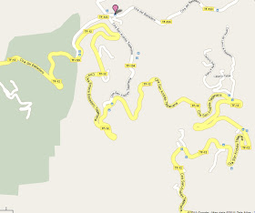
after leaving this particular view point we continue the drive up into the mountains along the many winding roads as seen here on the following map:
we often had to pass another bus or vehicle, the only way to do this was for one vehicle to pull over or back up into a lay way. I commend the drivers that do this daily as the roads are very narrow and with no safety rail's:
next blog posting will be more of the beautiful scenery we saw whilst on this tour ...
for the previous blog posts on Tenerife see below:
1. arriving early morning in the Canary Islands (click here)
2. The Holy Christ of La Laguna (click here)
3. a wander around La Laguna (click here)
stay tuned for further updates!!
=============================================


No comments:
Post a Comment